![](/images/other/stat-length.png)
![Tour Schneeschuhwandern Val de Bagnes - N° 1 Mayens du Châble - Photo](https://media.geolcdn.com/t/1900/400/ext.pjpeg?maxdim=2&url=https%3A%2F%2Fstatic1.geolcdn.com%2Fsiteimages%2Fupload%2Ffiles%2F1524743153raquette.jpg)
N° 1 Mayens du Châble
verbier
Benutzer
![Länge](/images/other/stat-length.png)
Länge
6,6 km
![Maximale Höhe](https://static1.geolcdn.com/siteimages/upload/files/1508320355ic_sort_altitude_max_24dp.png)
Maximale Höhe
1705 m
![Positive Höhendifferenz](https://static1.geolcdn.com/siteimages/upload/files/1508320355ic_sort_den_pos_24dp.png)
Positive Höhendifferenz
871 m
![Km-Effort](/images/other/stat-length.png)
Km-Effort
15,4 km
![Min. Höhe](https://static1.geolcdn.com/siteimages/upload/files/1508320355ic_sort_altitude_min_24dp.png)
Min. Höhe
864 m
![Negative Höhendifferenz](https://static1.geolcdn.com/siteimages/upload/files/1508320355ic_sort_den_neg_24dp.png)
Negative Höhendifferenz
38 m
![Boucle](https://static1.geolcdn.com/siteimages/upload/files/16400158638029165_repeat_loop_refresh_sync_direction_icon.png)
Boucle
Nein
Erstellungsdatum :
2014-12-10 00:00:00.0
Letzte Änderung :
2014-12-10 00:00:00.0
![Schneeschuhwandern](https://static1.geolcdn.com/sitytour/trail-icons/504.png)
3h30
Schwierigkeit : Unbekannt
![Scannen Sie diesen QR-Code, um die Tour in der SityTrail-Anwendung zu öffnen](https://capi.geolives.com/qq0zvz2zws4bq2lad0pu/sitytour/trails/46196/qr.png?size=200)
Kostenlosegpshiking-Anwendung
Über SityTrail
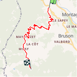
Tour Schneeschuhwandern von 6,6 km verfügbar auf Wallis, Entremont, Val de Bagnes. Diese Tour wird von verbier vorgeschlagen.
Beschreibung
Le Châble Bahnhof - Clouchère''s Strasse - Les Barmes (1''066 m) - La Diète (1''231 m) - Les Combes - Le Mayentset (1''567 m) - Moay''s Restaurant - La Vinteure - Mayens de Bruson
Ort
Land:
Switzerland
Region :
Wallis
Abteilung/Provinz :
Entremont
Kommune :
Val de Bagnes
Standort:
Unknown
Gehen Sie:(Dec)
Gehen Sie:(UTM)
361517 ; 5104188 (32T) N.
Kommentare
Touren in der Umgebung
![Tour Zu Fuß Val de Bagnes - Vollèges - Levron - Photo](https://media.geolcdn.com/t/375/260/000ad3aa-b35f-4d3f-9d12-9568cd1e719d.jpeg&format=jpg&maxdim=2)
![Zu Fuß Zu Fuß](https://static1.geolcdn.com/sitytour/trail-icons/100.png)
Vollèges - Levron
Zu Fuß
Einfach
Val de Bagnes,
Wallis,
Entremont,
Switzerland
![](/images/other/stat-length.png)
3,3 km | 7,8 km-effort
1h 46min
![](https://static1.geolcdn.com/siteimages/upload/files/16400158638029165_repeat_loop_refresh_sync_direction_icon.png)
Nein
![Tour Zu Fuß Val de Bagnes - Vollèges - Levron - Photo](https://media.geolcdn.com/t/375/260/000ad3aa-b35f-4d3f-9d12-9568cd1e719d.jpeg&format=jpg&maxdim=2)
![Zu Fuß Zu Fuß](https://static1.geolcdn.com/sitytour/trail-icons/100.png)
Vollèges - Levron
Zu Fuß
Einfach
Val de Bagnes,
Wallis,
Entremont,
Switzerland
![](/images/other/stat-length.png)
5,4 km | 10,3 km-effort
2h 20min
![](https://static1.geolcdn.com/siteimages/upload/files/16400158638029165_repeat_loop_refresh_sync_direction_icon.png)
Nein
![Tour Zu Fuß Orsières - Chemins pédestre, commune d'Orsières - Photo](https://media.geolcdn.com/t/375/260/70edd484-9073-4e02-96d0-3d17425bab34.jpeg&format=jpg&maxdim=2)
![Zu Fuß Zu Fuß](https://static1.geolcdn.com/sitytour/trail-icons/100.png)
Chemins pédestre, commune d'Orsières
Zu Fuß
Einfach
Orsières,
Wallis,
Entremont,
Switzerland
![](/images/other/stat-length.png)
5,4 km | 14,1 km-effort
3h 12min
![](https://static1.geolcdn.com/siteimages/upload/files/16400158638029165_repeat_loop_refresh_sync_direction_icon.png)
Nein
![Tour Zu Fuß Val de Bagnes - Ancien Bisse du Levron - Photo](https://media.geolcdn.com/t/375/260/80610014-2440-48cc-bb45-b16896750006.jpeg&format=jpg&maxdim=2)
![Zu Fuß Zu Fuß](https://static1.geolcdn.com/sitytour/trail-icons/100.png)
Ancien Bisse du Levron
Zu Fuß
Einfach
Val de Bagnes,
Wallis,
Entremont,
Switzerland
![](/images/other/stat-length.png)
10,7 km | 13,4 km-effort
3h 2min
![](https://static1.geolcdn.com/siteimages/upload/files/16400158638029165_repeat_loop_refresh_sync_direction_icon.png)
Nein
![Tour Wandern Val de Bagnes - La Haute Route : J2 - Photo](https://media.geolcdn.com/t/375/260/180b2b28-d72b-4e1f-bcdd-fa58e937cbf2.jpg&format=jpg&maxdim=2)
![Wandern Wandern](https://static1.geolcdn.com/sitytour/trail-icons/101.png)
La Haute Route : J2
Wandern
Schwierig
Val de Bagnes,
Wallis,
Entremont,
Switzerland
![](/images/other/stat-length.png)
12,4 km | 21 km-effort
3h 37min
![](https://static1.geolcdn.com/siteimages/upload/files/16400158638029165_repeat_loop_refresh_sync_direction_icon.png)
Nein
![Tour Zu Fuß Val de Bagnes - Promenade de la Dranse - Photo](https://media.geolcdn.com/t/375/260/086adfed-46f4-4991-8417-75cd394f8ae1.jpeg&format=jpg&maxdim=2)
![Zu Fuß Zu Fuß](https://static1.geolcdn.com/sitytour/trail-icons/100.png)
Promenade de la Dranse
Zu Fuß
Einfach
Val de Bagnes,
Wallis,
Entremont,
Switzerland
![](/images/other/stat-length.png)
7,1 km | 9,4 km-effort
2h 8min
![](https://static1.geolcdn.com/siteimages/upload/files/16400158638029165_repeat_loop_refresh_sync_direction_icon.png)
Nein
![Tour Zu Fuß Val de Bagnes - Chemins pédestres, région Bagnes - Photo](https://media.geolcdn.com/t/375/260/8db834a7-d9d6-41f8-95ac-2756844d7a1f.jpeg&format=jpg&maxdim=2)
![Zu Fuß Zu Fuß](https://static1.geolcdn.com/sitytour/trail-icons/100.png)
Chemins pédestres, région Bagnes
Zu Fuß
Einfach
Val de Bagnes,
Wallis,
Entremont,
Switzerland
![](/images/other/stat-length.png)
6,2 km | 15 km-effort
3h 24min
![](https://static1.geolcdn.com/siteimages/upload/files/16400158638029165_repeat_loop_refresh_sync_direction_icon.png)
Nein
![Tour Zu Fuß Val de Bagnes - Bruson - Moay - Photo](https://media.geolcdn.com/t/375/260/086adfed-46f4-4991-8417-75cd394f8ae1.jpeg&format=jpg&maxdim=2)
![Zu Fuß Zu Fuß](https://static1.geolcdn.com/sitytour/trail-icons/100.png)
Bruson - Moay
Zu Fuß
Einfach
Val de Bagnes,
Wallis,
Entremont,
Switzerland
![](/images/other/stat-length.png)
3,6 km | 10 km-effort
2h 16min
![](https://static1.geolcdn.com/siteimages/upload/files/16400158638029165_repeat_loop_refresh_sync_direction_icon.png)
Nein
![Tour Wandern Riddes - Croix de Coeur - Pierre Avoi - Photo](https://media.geolcdn.com/t/375/260/ext.jpg?maxdim=2&url=https%3A%2F%2Fstatic1.geolcdn.com%2Fsiteimages%2Fupload%2Ffiles%2F1553511878bg_sport_marche.png)
![Wandern Wandern](https://static1.geolcdn.com/sitytour/trail-icons/101.png)
Croix de Coeur - Pierre Avoi
Wandern
Medium
(2)
Riddes,
Wallis,
Martinach,
Switzerland
![](/images/other/stat-length.png)
6,4 km | 10,9 km-effort
2h 26min
![](https://static1.geolcdn.com/siteimages/upload/files/16400158638029165_repeat_loop_refresh_sync_direction_icon.png)
Ja